Flood Management
AILA
Flood Management Scheme “Reconstruction, Remodeling and Improvement of embankments in Sundarban and adjoining areas in the districts of North & South 24-Parganas, West Bengal , damaged by severe cyclone AILA” being executed by Irrigation & Waterways Department, Government of West Bengal
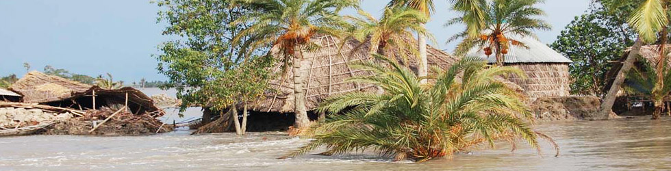
Devastation of Severe Cyclone 'AILA' in 2009
Severe cyclone ‘Aila’ hit the coastal parts of West Bengal, particularly in South 24-Parganas and North 24-Parganasat around 14.00 hours on 25th May 2009, with wind speed ranging between 120 to 130 kmph and it continued its devastating journey northwards affecting the districts of North 24-Pargnas, Purba Medinipur, Kolkata, Howrah, Hooghly, Burdwan, Birbhum, Uttar Dinajpur, Dakshin Dinajpur and Darjeeling with gradually weakening intensity. Height of tidal surge of swollen sea, exacerbated by the occurrence of the new moon the day after was observed to be around 3.3 more than the predicted level at Sagar Island. Overtopping of embankments occurred at numerous locations, leading to either total collapse or severe damage. Tidal waves entered into the countryside by overtopping or breaching the embankment and damaged thousands of houses and hutments,, washed away roads and inundated huge areas in Sundarban and adjoining areas in the districts of North & South 24-Parganas. Out of total girdle of about 3122 km lengths of embankment maintained by the Irrigation & Waterways Department, wash out / breaches occurred in about 177 km length and a further 601 km length in numerous stretches suffered severe damage. Unless the reconstruction works are taken up immediately after the monsoon, the entire stretch of 778 km of embankments (either washed away or severely damaged by ‘Aila’) would be susceptible to failure under the possible attack at cyclone in future, even of much lesser magnitude compared to ‘Aila’.
Constitution of task forceby the Government of India
In the aftermath of ‘Aila’, a Task Force on ‘Restoration of Sundarban embankments damaged by the cyclone Aila’ was constituted by the Union Ministry of Water Resources in May 2009.
The Irrigation & Waterways Department submitted a proposal to the Task Force for undertaking reconstruction works of total 778 km length of embankment (177 km washed away or breached and 601 km severely damaged) as short-term measures in its 2nd meeting and thereafter a Flood Management Project has been formulated based generally on the recommendations of the Task Force.
Categorization of works in the Project
Depending on the nature of damage and methodology to be adopted for reconstruction / improvement works, following six categories of execution have been considered.
| Category | Description | Total straight length (in Km) |
| 1A | Reconstruction of washed out sea dykes having Geo-tube core to be filled by dredged sand from sea but embankments to be constructed by local earth from countryside, along with block pitching on sea-side slope. | 10.20 |
| 1B | Reconstruction of washed out river embankment in critical locations (length in individual stretch around 1 km or more) by dredged riverbed materials, along with block pitching on riverside slope. | 28.80 |
| 1C | Reconstruction of washed out / breached river embankment at other locations (length in individual stretch generally less than 1 km) by local earth from countryside, along with block pitching on riverside slope. | 137.90 |
| 2A | Reconstruction / improvement of severely damaged sea dyke by local earth from countryside, along with block pitching on seaside slope. | 8.75 |
| 2B | Reconstruction / improvement of severely damaged river embankment by local earth from countryside or other suitable places and with block pitching on countryside slope, along with block pitching on riverside slope. | 477.10 |
| 2C | Reconstruction / improvement of severely damaged river embankment by local earth from countryside or other suitable places but without block pitching on riverside slope. | 115.00 |
| Total | 777.75 | |
| Say | 778.00 Km |
Total approved cost of the project = 5032.00 crores
The scheme has been approved Techno-economically initially by the Ganga Flood Control Commission and also by the Advisory Committee on Irrigation, Flood Control and Multipurpose project of MoWR in their 102nd meeting held on 28.01.2010.
The Investment Clearance was accorded thereon by the Planning Commission, Government of India on 26/07/2010 to the approved cost of Rs.5032.00 Crore.
The project was included under the funding of Flood Management Programme (FMP), a State Sector scheme of Ministry of Water Resources, by the Empowered Committee on FMP in their 6thmeeting at an estimated cost 1339.50 crores for the construction of Phase-I portion. The Phase-I includes construction of 183 K.M of embankment.