Irrigation Section
The river Damodar has a basin area of 58,480 sq. km. of which 32,110 sq. km. is in Jharkhand (erstwhile Bihar). A comprehensive programme of flood control, irrigation and power generation was planned under a corporation with participation of Bihar, West Bengal and Govt. of India. DVC was formed in 1948. Four dams situated in Jharkhand is complete though acquisition of some flood storage areas still remains incomplete. The irrigation and canal system of DVC has been handed over to the Govt. of West Bengal in 1964.
In the original project DVC canal system was designed mainly to provide irrigation in Kharif and Rabi period. Now, the system has started providing irrigation to summer paddy also. At present further work for increasing irrigation coverage by reducing transmission losses and changing cropping pattern has been taken up.
An irrigation potential of 4,83,500 ha. out of its ultimate irrigation potential of 5,10,110 ha. has been created through the project in the districts of Burdwan, Bankura, Hooghly and Howrah.
Salient Features
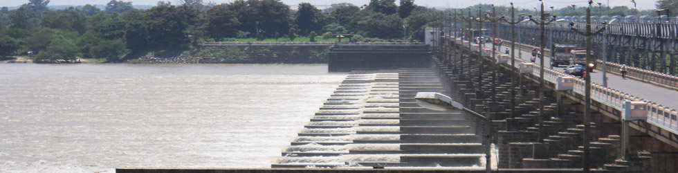
| Durgapur Barrage (DVC Project) | |
| Location | Durgapur, District Burdwan on the river – Damodar |
| Catchment area | 19.547 sq. km. (7,635 sq. Mile) Damodar – Barakar Basin |
| Width Between Abutments | 692 m (2271 ft.) |
| No. of Weir Bays | 24 – Each width 18.29 m+ Under Sluice Bays – 10 (Each width 18.3 m) |
| Linear Waterway | 622 m (2,040 ft.) |
| Design Discharge | 15,574 cumecs (5,50,000 cusecs) |
| Optimum Pond Level | 64.48 m (211.50 ft.) |
| Design Upstream Level | 64.08 m (210.20 ft.) |
| Canal Discharge | Left - 259 cumecs (9,146 cusecs) Right - 64 cumecs (2,260 cusecs) |
| Irrigable Area | Kharif - 3,93,768 ha (9,73,000 acre) Rabi - 22,258 ha (55,000 acre) |
| Maximum Irrigation | Kharif - 3,33,200 ha (8,23,000 acre) Rabi - 18,450 ha (45,580 acre) Boro - 69,790 ha (1,72,400 acre) |